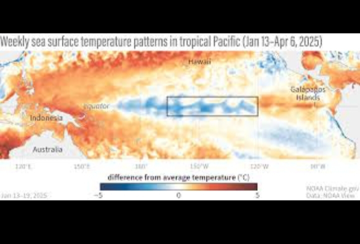
$ENSO La Niña-Bedingungen sind weiterhin offiziell im tropischen Pazifik vorhanden, gekennzeichnet durch unterdurchschnittliche Meerestemperaturen (SSTs) im äquatorialen Pazifik - insbesondere in wichtigen Niño-Regionen, die von Vorhersagern genutzt werden. Diese La Niña ist jedoch schwach und nimmt ab.
ENSO-Alarm-System: Die La Niña-Warnung bleibt ab Anfang Februar 2026 in Kraft.
SST-Anomalien in der Niño-3.4-Region (ein wichtiger ENSO-Index) liegen unter dem Durchschnitt, nähern sich jedoch der Neutralität.
Atmosphärische Muster (Passatwinde, Konvektion) sind mit La Niña konsistent, schwächen jedoch.
📈 Übergang zu ENSO-Neutral wahrscheinlich
Vorhersager erwarten, dass La Niña schwächer wird und in neutrale ENSO-Bedingungen (weder La Niña noch El Niño) übergeht, während Januar–März 2026 mit hoher Wahrscheinlichkeit. Neutrale Bedingungen werden voraussichtlich bis spät in den Frühling 2026 anhalten.
Das Klimavorhersagezentrum der NOAA gibt eine ~75% Chance auf neutrale Bedingungen bis spät im Frühling der Nordhalbkugel an.
ENSO-neutral bedeutet, dass die SSTs im tropischen Pazifik nahe dem Durchschnitt liegen und die typischen La Niña/El Niño-atmosphärischen Einflüsse schwächer werden.
📊 Vorhersageausblick
ENSO-Vorhersagemodelle (z. B. IRI-Konsens) zeigen an:
La Niña-Wahrscheinlichkeiten fallen bis Anfang 2026.
ENSO-neutral ist am wahrscheinlichsten im Frühling und frühen Sommer.
Über das mittlere Jahr hinaus steigen die Chancen auf das Auftreten von El Niño, obwohl langfristige Vorhersagen aufgrund der Frühjahrs-Vorhersagbarkeitsschranke weiterhin unsicher sind.
📌 Was das für das Wetter bedeutet
ENSO beeinflusst globale Wetterlagen:
La Niña bringt typischerweise kühlere, feuchtere Bedingungen in einige Regionen und trockenere Bedingungen in andere.
ENSO-neutral bedeutet weniger ENSO-gesteuerten Einfluss auf saisonale Wetterextreme.
Falls El Niño später im Jahr 2026 auftreten sollte, könnte es die globalen Temperaturschemata verschieben und die Hurrikanaktivität sowie das Monsunverhalten beeinflussen.#RiskAssetsMarketShock #JPMorganSaysBTCOverGold #WarshFedPolicyOutlook #WhenWillBTCRebound #EthereumLayer2Rethink?